The short answer
Drone photography gives buyers the context photos cannot: lot size, views, and neighborhood. In San Diego it must follow FAA airspace rules, which matters most near the coast and the airport.
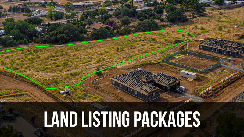
What drone adds to a listing
Aerial photography answers the questions a buyer cannot ask from a floor plan. How big is the lot? What is next door? How close is the beach, the canyon, the park? A few well-composed drone shots establish the setting and the value of a property in seconds.
For view homes, land, and estates on acreage, drone is not a nice-to-have. It is the only way to convey what makes the property worth its price.
How FAA rules affect San Diego flights
Drone flights for real estate are commercial operations and must follow FAA guidelines. Parts of San Diego sit in controlled airspace, especially near San Diego International, Montgomery Field, and stretches of the coast, where flights need authorization or may not be permitted at all.
A professional team knows how to check airspace before the shoot and stays compliant. When a location is restricted, we tell you in advance and substitute additional ground coverage so the listing never goes short.
When drone is worth it
- View properties where the view is a primary selling point.
- Land and vineyard listings that need boundary outlines and scale.
- Estates on acreage where grounds and privacy drive value.
- Master-planned communities where amenities and proximity matter.
Frequently asked
Can you fly a drone over any San Diego home?
Not always. Some areas near the airport and the coast are restricted airspace under FAA rules. We check airspace before every shoot and let you know if a location is limited.
How much does drone photography cost?
Drone is included in most of our listing packages. As a standalone add-on it starts at $150.